West Point track
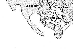
The 8-km walk from Picnic Bay to West Point is a great opportunity to access some of the diverse habitats of Magnetic Island and gain an appreciation of what the Island may have been like prior to development. The western side of Magnetic Island is quite different from the north- and easterly facing bays. The latter have sandy beaches and rocky headlands, while the western side has sheltered bays protected by mangrove forests, saltpans, mudflats and fringing reef. The generally undisturbed state of the western side of the Island affords great opportunities for viewing wildlife in its natural environment.
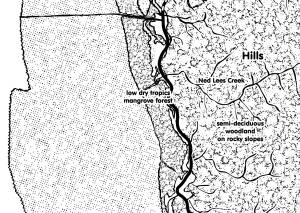
The first 3 km of the track is a bitumen-sealed road, made from a coral spoil road base. On the seaward side of the bitumen track you will see a low dry tropics mangrove forest interspersed with salt-water couch (Sporobolis virginicus) and salt-tolerating grassland. On the landward side a steep slope of granite boulders leads high into the hills, with pockets of semi-deciduous woodland protected from fire throughout.
At the end of the bitumen track you may notice the large water tank. This is the pump station where the water comes from town.
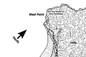
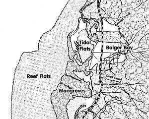
The start of the 5-km dirt track brings you immediately up Goldmine Hill. As you descend the hill you enter Bolger Bay, which is the least developed of the Island bays. Historical small market gardens and limited cattle grazing were the main land use, while today most of the bay is bush blocks under freehold ownership. All sidetracks and side roads lead to private property.
The diversity of open woodland with closed riparian areas and pockets of vine thicket, softwood scrubs, mangrove forest and saltpans allows great opportunities for bird watching, and all plant communities can be easily seen from the road. In many parts of the bay a continuous stretch of undeveloped bushland extends from the rocky hills to the mangrove forests.
At the end of the road you will find a beach nestled against the surrounding rocky hills and the community of West Point. This community is limited to beach houses on a large sand spit. For many years the only access to West Point was by boat. West Point is certainly the place to be for sunsets, where you can watch the sun set over the sea with the silhouette of the many rocky outcrops and small islands of Halifax Bay. From West Point you can look back to the mainland and see the spectacular headland and the dry coastal ranges of the Town Common. You can also see the township of Pallarenda stretched along its shore and on a clear day you may also see the lighthouse on Bay Rock.
|