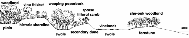
This sand, and a small amount of coral sand from the eroding reef flat, is constantly reworked and distributed along the beach by wave action, slowly building the shoreline outwards. Occasionally, cyclones catastrophically alter the distribution of dunal sand and beaches, but the sand is basically trapped in Horseshoe Bay and, as the shoreline slowly advances, minor dunes are left as relics of previous shorelines.
These coastal processes have developed a comprehensive dune/swale formation with open woodland of Moreton Bay ash (Corymbia tessellaris) and bloodwoods (Corymbia clarksoniana) on the older higher dunes, blue gum (Eucalyptus tereticornis) woodland-favoured lowland food of the koala (Phascolarctos cinereus)-on the lower swale country, and weeping paperbark (Melaleuca leucadendra) forests in the base of the swales.
A riparian closed forest follows the banks of Endeavour Creek with the occasional weeping paperbark and Moreton Bay ash as an emergent and dense vine thicket species underneath.
Apart from the lagoon wetland in the east of the bay, another wetland associated with the vegetation along Endeavour Creek contains a diverse mosaic of plant communities. It contains extensive areas of saltwater wetland (Sporobolis spp. and Paspalum spp.) grassland and smaller areas of freshwater and brackish habitat (Paspalum spp. and Brachiara spp.) grassland. This wetland provides important seasonal habitat and food for wildlife and is of high conservation value.
The unique vegetation of the older, higher dunes reflects the soil and water conditions that have resulted from the changing landforms. |